Climate Data for Latitude 39.75 Longitude 20.25Köppen climate classification: Csa (Climate: warm temperate; Precipitation: summer dry; Temperature: hot summer) Area of Oriokastro, Lake Delvinaki, Meropis forest, Gormou valley and Mounts Kasidiaris and Douskon
Kalamas estuary
Kalamas gorge
Mount Paramithias
Mounts Tsamanta, Filiaton, Pharmakovouni, and Megali Rahi
ORI TSAMANTA, FILIATON, FARMAKOVOUNI, MEGALI RACHI
OROS DOUSKON, ORAIOKASTRO, DASOS MEROPIS, KOILADA GORMOU, LIMNI DELVINAKIOU
STENA PARAKALAMOU
YGROTOPOS EKVOLON KALAMA KAI NISOS PRASOUDI
|
Averages (Metric) English| Type | Units | Jan | Feb | Mar | Apr | May | Jun | Jul | Aug | Sep | Oct | Nov | Dec | Period |
|---|
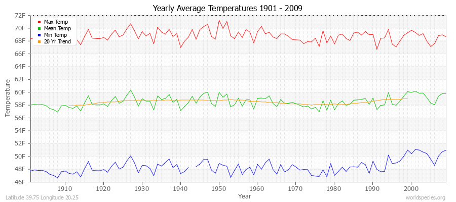
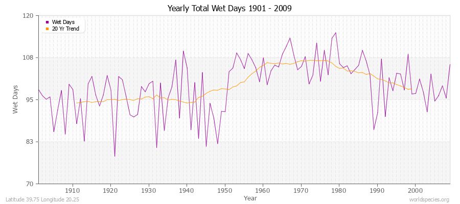
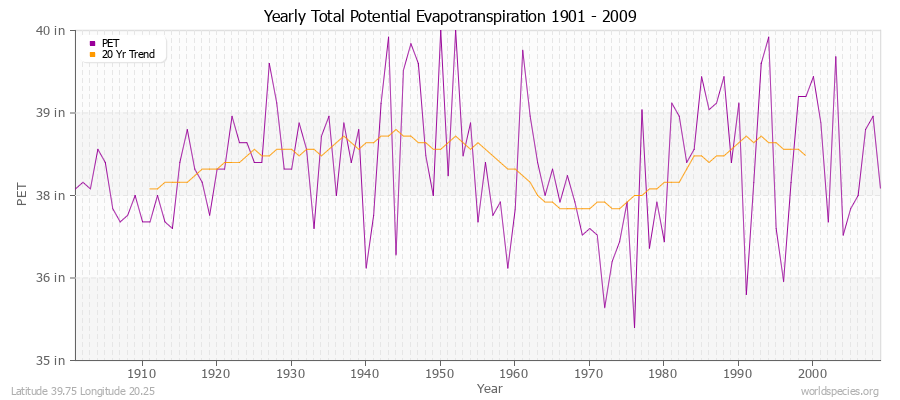
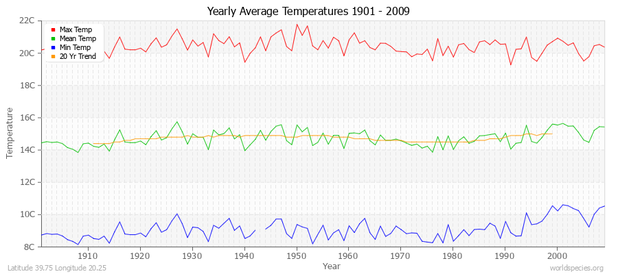
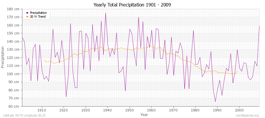
| Min Temp | C° | 1.7 | 2.5 | 4.6 | 7.5 | 11.1 | 14.4 | 16.5 | 16.7 | 13.8 | 10.4 | 6.7 | 3.4 | 108 years | | Mean Temp | C° | 6.0 | 7.0 | 9.6 | 12.9 | 17.2 | 21.1 | 23.7 | 24.0 | 20.4 | 16.0 | 11.4 | 7.5 | 109 years | | Max Temp | C° | 10.3 | 11.6 | 14.7 | 18.4 | 23.4 | 27.7 | 31.1 | 31.3 | 27.0 | 21.6 | 16.1 | 11.8 | 109 years | | Frost | Days | 20.4 | 15.7 | 12.4 | 4.2 | 2.1 | 1.0 | 1.0 | 3.0 | 6.0 | 5.3 | 17.1 | 15.9 | 1 years | | Wet | Days | 12.0 | 10.9 | 10.8 | 10.7 | 8.4 | 4.7 | 2.8 | 2.5 | 3.2 | 7.6 | 12.4 | 13.2 | 109 years | | Precipitation | mm | 168.7 | 147.8 | 101.8 | 85.9 | 50.4 | 21.6 | 13.1 | 14.6 | 63.0 | 137.7 | 180.7 | 208.9 | 109 years | | Potential Evapotranspiration | mm | 22.4 | 32.4 | 56.5 | 79.3 | 114.9 | 142.5 | 171.0 | 147.3 | 95.3 | 54.1 | 28.1 | 20.0 | 109 years |
Averages (English) Metric| Type | Units | Jan | Feb | Mar | Apr | May | Jun | Jul | Aug | Sep | Oct | Nov | Dec | Period |
|---|
| Min Temp | F° | 35.0 | 36.5 | 40.2 | 45.5 | 52.0 | 58.0 | 61.7 | 62.1 | 56.9 | 50.7 | 44.0 | 38.0 | 108 years | | Mean Temp | F° | 42.7 | 44.7 | 49.3 | 55.2 | 63.0 | 69.9 | 74.7 | 75.1 | 68.7 | 60.8 | 52.4 | 45.6 | 109 years | | Max Temp | F° | 50.5 | 52.9 | 58.4 | 65.0 | 74.1 | 81.9 | 87.9 | 88.3 | 80.6 | 70.9 | 60.9 | 53.2 | 109 years | | Frost | Days | 20.4 | 15.7 | 12.4 | 4.2 | 2.1 | 1.0 | 1.0 | 3.0 | 6.0 | 5.3 | 17.1 | 15.9 | 1 years | | Wet | Days | 12.0 | 10.9 | 10.8 | 10.7 | 8.4 | 4.7 | 2.8 | 2.5 | 3.2 | 7.6 | 12.4 | 13.2 | 109 years | | Precipitation | in | 6.6 | 5.8 | 4.0 | 3.4 | 2.0 | 0.8 | 0.5 | 0.6 | 2.5 | 5.4 | 7.1 | 8.2 | 109 years | | Potential Evapotranspiration | in | 0.9 | 1.3 | 2.2 | 3.1 | 4.5 | 5.6 | 6.7 | 5.8 | 3.8 | 2.1 | 1.1 | 0.8 | 109 years |
Climate data provided by CRU TS 3.1 - University of East Anglia Climate Research Unit (CRU). [Phil Jones, Ian Harris]. CRU Time Series (TS) high resolution gridded datasets, [Internet]. NCAS British Atmospheric Data Centre, 2008, Accessed: 28-July-2011 Charting software provided by pChart - a PHP class to build charts. The calculation method for the potential evapotranspiration is the FAO grass reference equation (Ekstrom et al., 2007, which is based on Allen et al., 1994).
It is a variant of the Penman Monteith method using TMP, TMN, TMX, VAP, CLD.
|