Climate Data for Latitude 49.75 Longitude 5.75

Köppen climate classification: Cfb (Climate: warm temperate; Precipitation: fully humid; Temperature: warm summer)
 

Locations

Download
Bassin de l'Attert (Attert)
Bassin de la Semois de Etalle à Tintigny (Etalle; Habay; Tintigny)
Bassin du Ruisseau du Messancy (Arlon; Messancy)
Bassin supérieur de la Vire et du Ton (Aubange; Messancy; Musson; Saint-Léger; Virton)
Bassin supérieur de la Wiltz (Bastogne)
Camp militaire de Lagland (Arlon; Etalle; Saint-Léger)
Forêt d'Anlier (Habay; Léglise; Martelange)
Forêts et marais bajociens de Baranzy à Athus (Aubange; Musson)
Haute-Sûre (Fauvillers; Léglise; Libramont-Chevigny; Neufchâteau; Vaux-sur-Sûre)
Haute-Sûre (Fauvillers; Léglise; Neufchâteau; Vaux-sur-Sûre)
Marais de la Haute-Semois et Bois de Heinsch (Arlon; Attert; Etalle; Habay)
Mare de Frassem (Arlon)
Mines of the region of Differdange
Region of the Middle Lias
Sinémurienne
Sûre frontalière (Fauvillers; Martelange)
Upper Valley of the Sure
Vallée de Villers-la-Bonne-Eau (Bastogne)
Vallée du Ton et Côte bajocienne de Montquintin à Ruette (Meix-devant-Virton; Rouvroy; Virton)
Vallées de l'Eisch et de Clairefontaine (Arlon)
Vallées de la Vire et du Ton (Rouvroy; Virton)
Vallées de Laclaireau et du Rabais (Etalle; Saint-Léger; Virton)
Vallées du Ruisseau de Mellier et de la Mandebras (Habay; Léglise; Neufchâteau)
Valley of the Attert

Averages (English) Metric

TypeUnitsJanFebMarAprMayJunJulAugSepOctNovDecPeriod
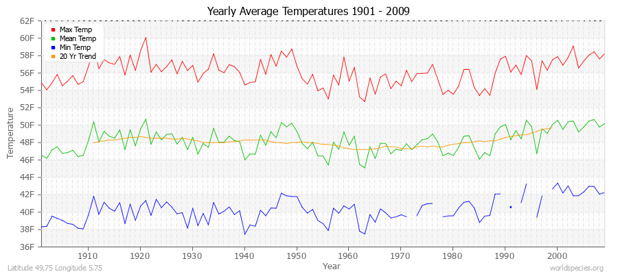
Min Temp28.228.532.937.645.150.153.352.847.941.534.930.1103 years
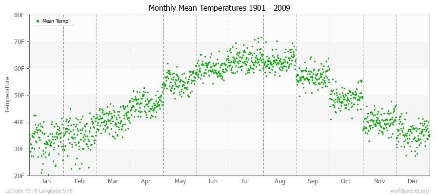
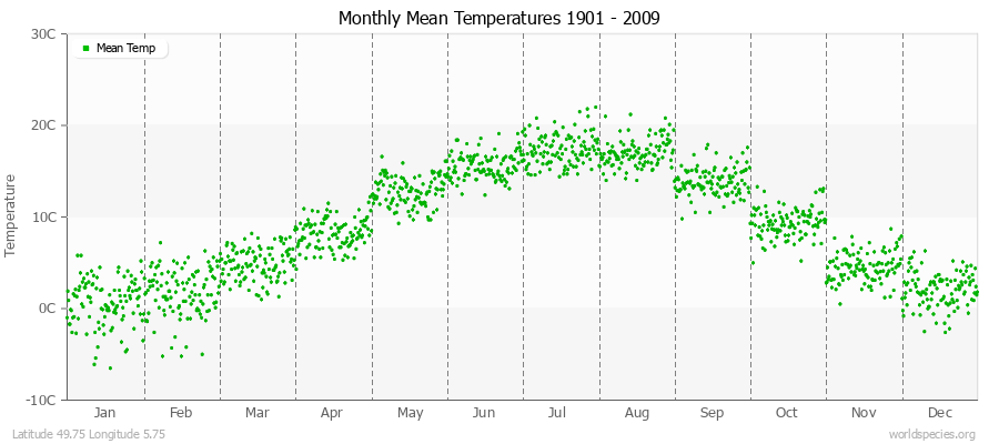
Mean Temp33.235.040.746.854.960.163.362.657.048.940.135.7109 years
Max Temp38.041.248.556.064.870.273.472.466.156.345.441.3109 years
FrostDays31.028.226.916.17.21.11.71.85.013.824.031.06 years
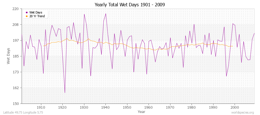
WetDays19.815.217.115.116.014.313.214.015.416.218.318.8109 years
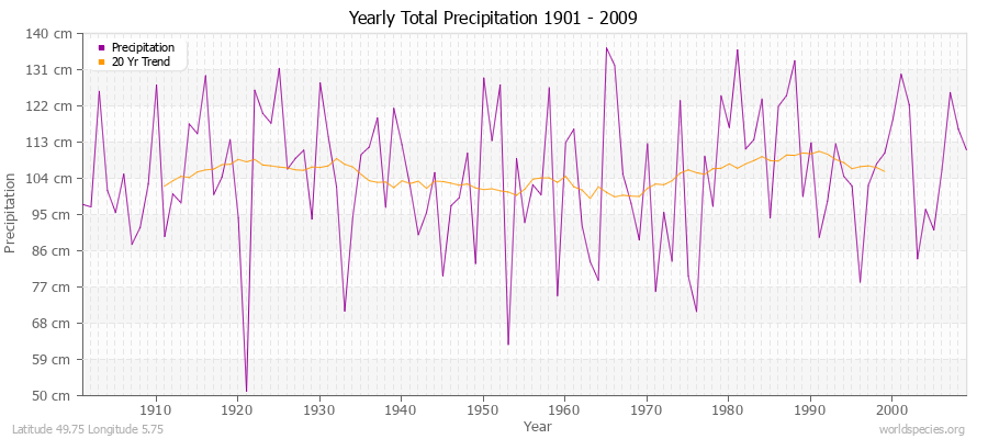
Precipitationin4.33.33.22.83.02.93.33.13.13.44.34.6109 years
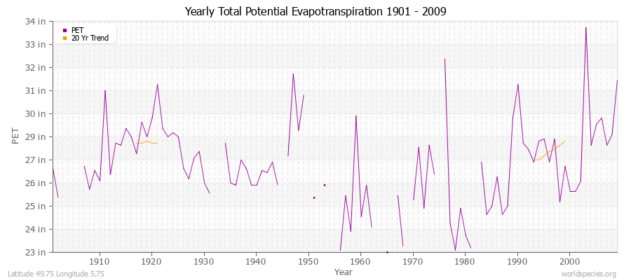
Potential Evapotranspirationin0.40.81.62.73.94.24.63.92.61.40.60.492 years
Yearly Average Temperatures 2010 - 2009 (English) Latitude 49.75 Longitude 5.75
Monthly Mean Temperatures 1901 - 2009 (English) Latitude 49.75 Longitude 5.75
Yearly Total Frost Days 1906 - 2009 Latitude 49.75 Longitude 5.75
Yearly Total Precipitation 1901 - 2009 (English) Latitude 49.75 Longitude 5.75
Yearly Total Wet Days 1901 - 2009 Latitude 49.75 Longitude 5.75
Yearly Total Potential Evapotranspiration 1901 - 2009 (English) Latitude 49.75 Longitude 5.75

Climate data provided by CRU TS 3.1 - University of East Anglia Climate Research Unit (CRU). [Phil Jones, Ian Harris]. CRU Time Series (TS) high resolution gridded datasets, [Internet]. NCAS British Atmospheric Data Centre, 2008, Accessed: 28-July-2011
Charting software provided by pChart - a PHP class to build charts.
Köppen climate classification provided by Kottek, M., J. Grieser, C. Beck, B. Rudolf, and F. Rubel, 2006: World Map of Köppen-Geiger Climate Classification updated. Meteorol. Z., 15, 259-263
The calculation method for the potential evapotranspiration is the FAO grass reference equation (Ekstrom et al., 2007, which is based on Allen et al., 1994). It is a variant of the Penman Monteith method using TMP, TMN, TMX, VAP, CLD.