Climate Data for Latitude 42.75 Longitude -1.25Köppen climate classification: Cfb (Climate: warm temperate; Precipitation: fully humid; Temperature: warm summer) Arabarko
Areta, Archuba and Zariquieta mountain ranges
Izaga crag
Leyre, Illón and San Miguel mountain ranges
Roncesvalles-Irati-Abodi mountain range
Roncesvalles-Selva de Irati
Sierra de Artxuga, Zarikieta y Montes de Areta
Sierra de Illón y Foz de Burgui
Sierra de Leire, Foz de Arbaiun
SIERRAS DE LEYRE Y ORBA
|
Averages (Metric) English| Type | Units | Jan | Feb | Mar | Apr | May | Jun | Jul | Aug | Sep | Oct | Nov | Dec | Period |
|---|
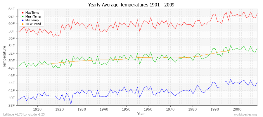
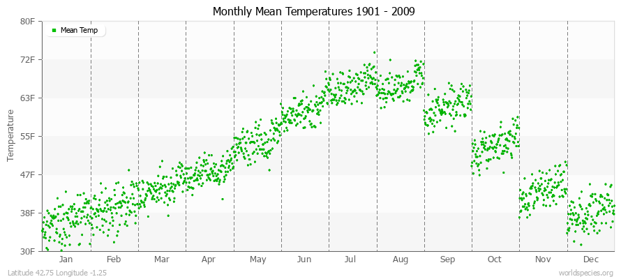
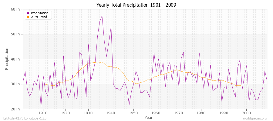
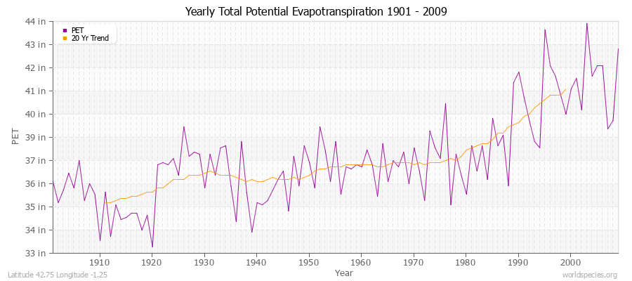
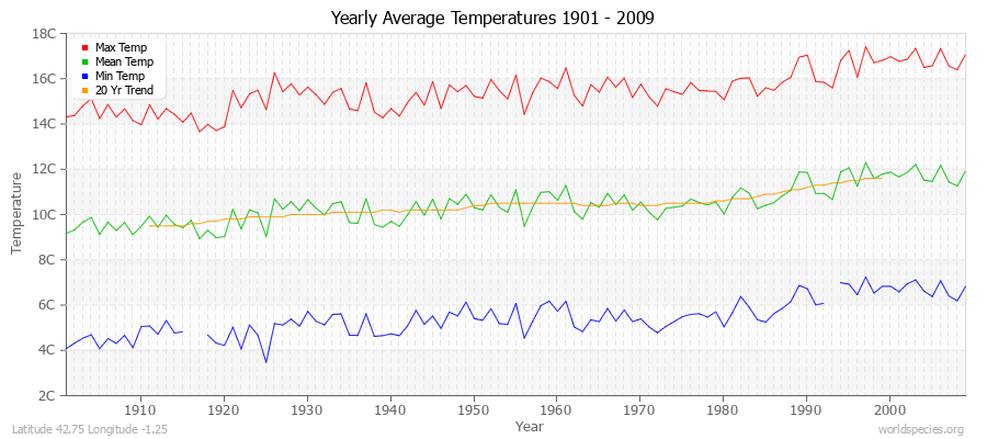
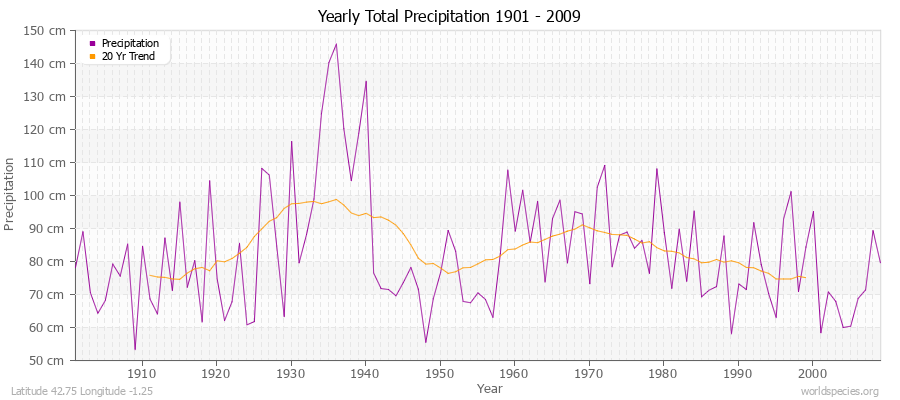
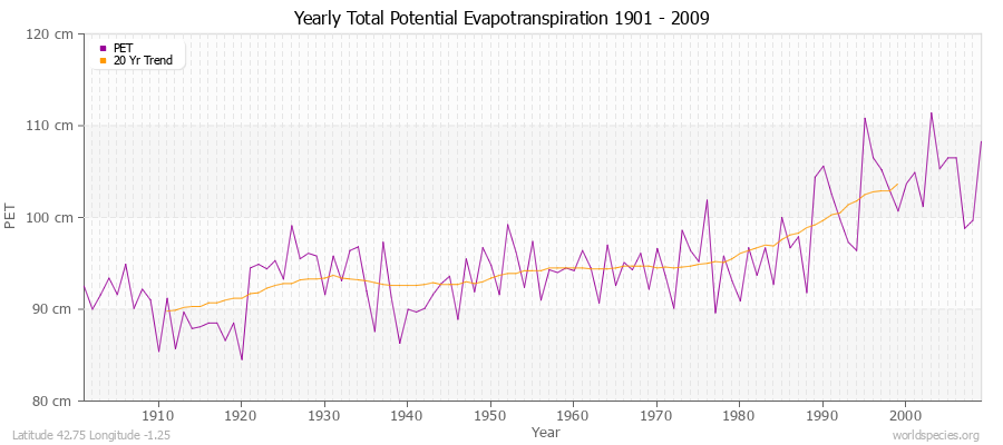
| Min Temp | C° | -0.9 | -0.1 | 1.7 | 3.6 | 6.6 | 9.9 | 12.3 | 12.4 | 10.4 | 6.9 | 2.4 | 0.3 | 106 years | | Mean Temp | C° | 2.6 | 4.1 | 6.5 | 8.4 | 12.0 | 15.9 | 18.9 | 18.9 | 16.3 | 11.6 | 6.2 | 3.6 | 109 years | | Max Temp | C° | 6.1 | 8.3 | 11.4 | 13.4 | 17.5 | 22.0 | 25.6 | 25.5 | 22.2 | 16.5 | 10.2 | 6.9 | 109 years | | Frost | Days | 31.0 | 28.2 | 25.8 | 19.9 | 5.8 | 5.5 | 2.9 | 1.5 | 5.1 | 11.9 | 23.5 | 30.6 | 109 years | | Wet | Days | 12.2 | 10.8 | 11.5 | 13.8 | 14.2 | 10.8 | 8.2 | 7.5 | 9.0 | 9.8 | 12.9 | 11.1 | 109 years | | Precipitation | mm | 69.8 | 62.3 | 68.2 | 79.4 | 90.4 | 64.3 | 38.7 | 48.9 | 63.7 | 78.4 | 82.2 | 81.2 | 109 years | | Potential Evapotranspiration | mm | 24.4 | 36.7 | 61.5 | 75.3 | 103.6 | 129.9 | 158.8 | 142.5 | 99.9 | 62.1 | 32.6 | 24.6 | 109 years |
Averages (English) Metric| Type | Units | Jan | Feb | Mar | Apr | May | Jun | Jul | Aug | Sep | Oct | Nov | Dec | Period |
|---|
| Min Temp | F° | 30.4 | 31.9 | 35.1 | 38.5 | 43.8 | 49.7 | 54.1 | 54.4 | 50.8 | 44.4 | 36.2 | 32.5 | 106 years | | Mean Temp | F° | 36.6 | 39.4 | 43.7 | 47.2 | 53.6 | 60.7 | 66.0 | 66.1 | 61.3 | 53.0 | 43.2 | 38.4 | 109 years | | Max Temp | F° | 42.9 | 46.9 | 52.4 | 56.1 | 63.5 | 71.7 | 78.1 | 77.8 | 72.0 | 61.7 | 50.3 | 44.4 | 109 years | | Frost | Days | 31.0 | 28.2 | 25.8 | 19.9 | 5.8 | 5.5 | 2.9 | 1.5 | 5.1 | 11.9 | 23.5 | 30.6 | 109 years | | Wet | Days | 12.2 | 10.8 | 11.5 | 13.8 | 14.2 | 10.8 | 8.2 | 7.5 | 9.0 | 9.8 | 12.9 | 11.1 | 109 years | | Precipitation | in | 2.7 | 2.5 | 2.7 | 3.1 | 3.6 | 2.5 | 1.5 | 1.9 | 2.5 | 3.1 | 3.2 | 3.2 | 109 years | | Potential Evapotranspiration | in | 1.0 | 1.4 | 2.4 | 3.0 | 4.1 | 5.1 | 6.3 | 5.6 | 3.9 | 2.4 | 1.3 | 1.0 | 109 years |
Climate data provided by CRU TS 3.1 - University of East Anglia Climate Research Unit (CRU). [Phil Jones, Ian Harris]. CRU Time Series (TS) high resolution gridded datasets, [Internet]. NCAS British Atmospheric Data Centre, 2008, Accessed: 28-July-2011 Charting software provided by pChart - a PHP class to build charts. The calculation method for the potential evapotranspiration is the FAO grass reference equation (Ekstrom et al., 2007, which is based on Allen et al., 1994).
It is a variant of the Penman Monteith method using TMP, TMN, TMX, VAP, CLD.
|